Made it to Alice Springs, via Adelaide -
After a night in Adelaide, we boarded the Ghan Railway to head north through the Outback to the small town of Alice Springs (if you can picture Australia, and the middle of it is the Outback, Alice Springs is in the middle of that). The Ghan, which is celebrating 80 years of connecting Adelaide in the south to Darwin in the north (hitting Alice Springs in the middle), is so named because it follows trails blazed by Afghan camel drivers in their quest to create a permanent path across the center of the continent. And looking at the scenery around the train, I can't imagine making this journey without a car or train. Either side is red dirt and sparse, scrubby bushes as far as the eye can see, under a hot sun and a cloudless sky. According to the on-board magazine, the first Ghan had plenty of trouble even after the tracks were laid - flash flooding could strand the train at on town or another, or even somewhere in the middle (legend has it that the train was once stranded for 10 days and the engineer fed his passengers by hunting wild goats), but in the 70s the railway was redone with a slightly different route out of most floodplains, as well as the addition of a more durable railway.
Sunrise in the Outback was amazing, though I do wish I could've gotten some sleep in before it... I took plenty of pictures, but I don't have a way of uploading them from this computer, so that'll have to wait until I'm back at UTS, when I'll document everything in more detail.
Anyway, right now the plan is to spend tomorrow in Alice Springs and then go on the 3 day hike the day after (a couple people came in who had to leave a day earlier than us and wanted to get on the earlier tour, so we gave them our spots since we had planned for an extra day in Alice Springs after the tour anyway). It ought to be a great trip!
Sunday, September 27, 2009
Friday, September 25, 2009
Spring Break!
It is now officially spring break, and I'm off to Alice Springs (by way of Adelaide) to go on a 3 day camping trip into the Outback to see Uluru (Ayers Rock) and all the other cool stuff there is out there. Here's the plan:
Tomorrow - Fly to Adelaide
Sunday - Board the train to Alice Springs for a 24 hour ride through the Outback
Monday - Arrive in Alice Springs
Tuesday - Meet up with the tour group and head out for three days and two nights in the bush
Saturday - Fly back to Adelaide
Sunday - Fly back to Sydney
I know the flight/train schedule is a little weird, but it was the cheapest way to get to Alice Springs (in total, about half the cost of a one-way flight to Alice Springs from Sydney).
Hopefullly the next post will be a picture of me standing next to a really big red rock...
Saturday, September 19, 2009
Sydney Half Marathon
Today, after a reeeeeally early wake-up call (4am), I ran the Sydney Half Marathon. We started at Milson's Point, right on the other side of the Harbour. The run took us across the Harbour Bridge, through the city, across another bridge right next to the ANZAC Bridge, then doubled back to the city to take us through Circular Quay to the finish at the Sydney Opera House (see map). This was my first half marathon, so I didn't really know how it was going to go, but with some good training tips (thanks Michael) I managed to finish in 1:44:47 by my watch, which is a lot faster than I expected to. My Ciy2Surf pace would have me finishing in just over 2 hours, and I was expecting to be slower towards the end of the longer distance. But the weather was perfect and I felt great.

Sunrise on the Harbour Bridge (you can se our final destination, the Opera House, just under the Bridge to the left)

Finish at the Opera House


The last 600m or so of the course are through Circular Quay, right next to the Harbour


After the finish there were food and drinks in the Royal Botanic Garden, which also happens to be a great place to lay out in the sun and relax.


I'd love to stay in the Garden all day, but unfortunately I have a Mechanics of Solids Midterm tomorrow, so it's off to study now...
Sunday, September 13, 2009
Rogaine
... and no, I don't mean the hair-loss product.
This weekend I went to Rydal, a small town in the Blue Mountains (about two hours or driving), with the UTS Outdoor Adventure Club for a rogaine skills workshop. Rogaining is a great outdoor sport, kind of like competitive orienteering, where small markers (a sheet of paper with a number on it) called "controls" are scattered throughout an area of bush and teams are given a set amount of time to use a compass and map of control locations to find as many as they can. Different controls are worth different points; rogaines can be anywhere from 2 to 24 hours long.
We were camped at the Rydal Showground with about 30 people from all over New South Wales. Over the weekend we had some classroom work on map and compass work, distance pacing, route planning, and basic strategy; we also went out on 4 short rogaines in the State Forests nearby. Our first was Saturday morning for about two hours, where we were split into groups of 5 with a guide - it was basically a practice session. That night we did a night rogaine (two hours again), which was a lot of fun. My flashlight wasn't particularly good, which made finding controls difficult, and it was harder to navigate based on landmarks when you can't see farther than a few meters, but it was good experience. Once time was up, it was time to make our way back to the Showground for tea and biscuits before climbing into our tents for the night.
Sunday morning we were up bright and early to go at it again, this time in a different forest. We saw quite a few wild kangaroos hopping around, usually running away from us when we came over a ridge. After that it was back to the showground for lunch and then our final two and a half hour competitive rogaine (no more guides, and this time the points count). We split up into teams of two; I was with a man named Rob who had done a few rogaines before (which meant he saw no problem with plowing through the thick bush down into and back out of steep gullies - it was a great hike). We ended up not doing as well as we had hoped after failing to find (and then spending too long looking for) two high point value controls, but it was still a lot of fun.
The landscape was amazing - and the stars even more so. It was like looking at the night sky in the Appalachian Mountains, except that the stars were completely unfamiliar. Really amazing.
While we were rogaining I tended to have a map in one hand and a compass in the other, but Rob had his camera out and got these shots of our group on the Sunday morning rogaine:
The Rydal Showground, with a daffodil field (we camped in an open area off to the left)

This is the basic terrain on this rogaine - thin trees and dry grass, with the occasional kangaroo

Our guide, Paddy, who showed us the ropes (and then tested us by taking our compasses away - really makes you follow the terrain rather than a bearing)
.JPG)
On the drive back to Sydney, we decided to make a short stop in the Blue Mountains (on a different part of the trail that I'd been on a few weeks ago) to see some amazing cliffs:

There were some incredible rock formations


One of the guys said this was a great cliff for rock climbing; you can see the shadow of the cliff we're standing on

Sunset in the Blue Mountains
Sunday, September 6, 2009
Blue Mountains Bushwalk
A couple weeks ago I made a great discovery - the UTS Outdoor Adventure Club, which runs bushwalking (in American, "hiking"), camping, rock climbing, and various other outdoorsy type trips. The first trip I joined was a bushwalk into the Blue Mountains (we started from the town of Blackheath, a two hour train ride west of Sydney). The weather forecast was for sunny skies and nice, 20 degree (Celsius) hiking weather.... until the morning of, when it decided to rain. We decided to go on with it however, and had a fantastic day hiking down into, through, and back up out of the canyon there, stopping for lunch during our convenient two hours of clear skies around noon, before hiking back to Blackheath along the rim of the canyon.


The canyon was not a "canyon" as I imagine the word - more like a jungle


Looking up

Looking down...

A small stream runs through it at the bottom

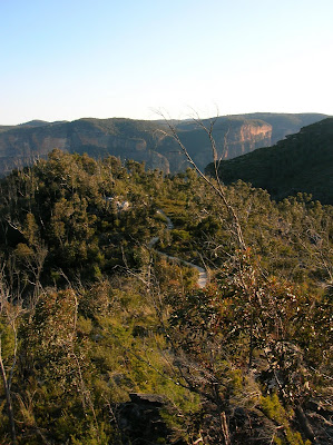
The view from Evan's Lookout


The wind picked up at just the right moment for this picture

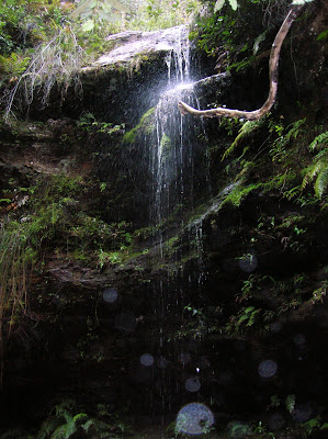
The waterfall, turned into mist by the wind, sustains a thick layer of moss on the adjacent rock face. According to the guide book, this moss sometimes becomes too heavy and falls to the valley floor below, adding to the supply of nutrient-rich soil below.


The Long and Winding Road...
The weather in Sydney has started to warm up, though it's a bit rainy again today. Pretty soon I think it will be great beach weather - the water is still freezing though.
Unfortunately, with this increased desire to go to the beach comes and increased workload... Last week I had to write a paper for my Introduction to Innovation describing an emerging technology. I chose carbon nanotube field emission displays (I didn't even know such a thing existed before I started poking through some books about carbon nanotubes). It's a pretty incredible technology, with the potential for very high definition flatscreen displays with great energy efficiency benefits over LCDs. I wouldn't be surprised if FEDs using carbon nanotubes start to appear as laptop displays within the next decade - they could offer great battery life.
One thing that I noticed while researching was the extent to which Rice is on the cutting edge of nanotechnology research. References to work done at Rice were scattered all through the books I read, and it really makes me proud to be able to go to a school like Rice.
Subscribe to:
Comments (Atom)
.jpg)


